Heavy Downpours and Stormy Skies: A Wet Friday Ahead for the Gold Coast
Wet Conditions to Dominate the Coast
Gold Coast residents should keep their umbrellas close at hand today, Friday, 27 February 2026, as a significant weather system moves across South East Queensland. Forecasters are predicting a very wet conclusion to the week, with heavy rainfall and potential thunderstorms expected to impact the region from the early morning through to the late evening hours.
Morning: Damp Starts and High Humidity
The day began with a thick blanket of cloud and early morning showers. Temperatures in the morning are hovering around 25°C, though the high humidity levels of approximately 84% may make it feel slightly warmer. There is an 80% chance of rain during the morning commute, so motorists are advised to take extra care on the Pacific Motorway and local arterial roads due to reduced visibility and slippery surfaces.
Afternoon: Heavy Rain and Thunderstorm Risks
Conditions are expected to intensify as we head into the afternoon. The temperature will reach a modest high of 24°C to 25°C, kept low by persistent cloud cover and precipitation. Meteorologists have flagged a 100% probability of rainfall during the day, with total accumulations expected to fall between 40mm and 50mm. This volume of water over a short period could lead to localized flash flooding in low-lying areas.
Key details for the afternoon include:
- Storm Potential: There is a moderate chance of a thunderstorm developing in the mid-to-late afternoon.
- Wind: Southeasterly winds will persist between 15 and 25 km/h, though gusts could reach higher speeds along the coastal fringe.
- Rainfall Intensity: Heavy falls are most likely between 1:00 PM and 4:00 PM.
Evening: Tapering Showers and Coastal Breezes
As evening approaches, the intensity of the rain is expected to ease slightly, though light rain and drizzle will likely continue into the night. Temperatures will dip to an overnight low of 22°C. While the heaviest of the rain may have passed, the southeasterly ridge remaining over the coast will keep conditions damp and breezy.
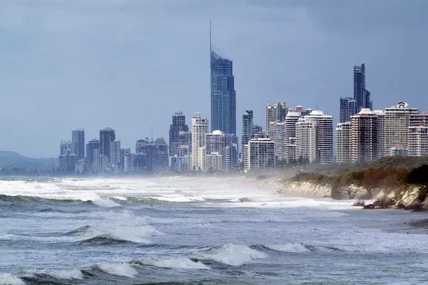
Marine and Surf Outlook
For those considering heading to the water, conditions are far from ideal. A ridge extending over southern Queensland waters is maintaining strong southeasterly winds of 20 to 25 knots, potentially reaching 30 knots offshore. Seas are expected to remain between 1.5 and 2 metres, with an easterly swell of 1.5 metres making for hazardous conditions for small craft. Beachgoers should remain cautious as the high chance of rain and potential storms make for a less-than-ideal day on the sand.

St. Patrick’s Day Shenanigans and Cultural Highlights: Gold Coast’s Top Tuesday Picks

Emerald Energy and Arena Ambitions: Your Gold Coast Tuesday Briefing

Heavy Coastal Congestion and Ridgevale Drive Closure: Tuesday Traffic Update