Batten Down the Hatches: Heavy Rain and Flash Flood Warnings Issued for Friday the 13th
Wet and Windy Friday the 13th for the Gold Coast
Gold Coast residents are advised to keep their umbrellas close and exercise extreme caution today, Friday, 13 February 2026. The weather is living up to its superstitious date, with the Bureau of Meteorology (BOM) and the City of Gold Coast issuing significant alerts for heavy rainfall, potential severe thunderstorms, and flash flooding across the region.
Morning: A Stormy Start
The day begins with a very high chance of rain, estimated at 90% to 100%. Early morning commuters can expect southerly winds between 15 and 25 km/h, which are predicted to shift to a stronger southeasterly flow of 25 to 35 km/h as the morning progresses. A severe thunderstorm warning is in place, with heavy falls likely to impact visibility and road conditions during the school run and morning rush.
Afternoon and Evening: Peak Rainfall and Flood Risks
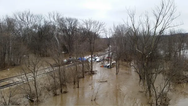
Conditions are expected to remain volatile through the afternoon. Temperatures will reach a modest maximum of 25°C, though high humidity near 90% will make it feel significantly warmer. The most critical concern for the afternoon is the risk of flash flooding. Total rainfall for the day is projected to be between 40mm and 130mm, with intense bursts possible during thunderstorm activity.
As we move into the evening, the rain is expected to persist, though it may transition into more steady, moderate falls. Overnight temperatures are forecast to dip to a minimum of 23°C, with a 55% chance of ongoing showers through the late-night hours.
Safety Alerts and Coastal Conditions
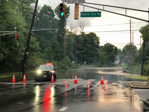
The City of Gold Coast has issued a "PREPARE NOW" notice for the local government area. While river catchments are currently stable, the risk of rapid runoff over urban surfaces is high. Key safety instructions include:
- Avoid driving, walking, or riding through floodwaters—if it's flooded, forget it.
- Stay informed via local radio and the Gold Coast Disaster and Emergency Dashboard.
- Campers and caravanners are urged to secure their sites or consider relocating.
For those on the water, a Minor Flood Watch is active until 6:30 PM this evening. Coastal winds may reach up to 30 knots, with seas increasing to 2.5 metres. While the UV index is predicted to reach an extreme level of 13, the thick cloud cover will provide some protection, though sun safety is still recommended if the sun breaks through.

Van Morrison Tributes and Midnight Dancing: What’s On in the Gold Coast Today
Burleigh Surfs Toward Sunshine: Your Tuesday Morning Briefing
Commuters Advised of Single-Lane Restrictions and Residual Flood Closures This Tuesday